


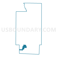
PRECINCT NEW FRANKLIN 4-C, Summit County, Ohio
About
Outline

Summary
| Unique Area Identifier | 652039 |
| Name | PRECINCT NEW FRANKLIN 4-C |
| County | Summit County |
| State | Ohio |
| Area (square miles) | 5.10 |
| Land Area (square miles) | 4.12 |
| Water Area (square miles) | 0.98 |
| % of Land Area | 80.86 |
| % of Water Area | 19.14 |
| Latitude of the Internal Point | 40.96017680 |
| Longtitude of the Internal Point | -81.59950650 |
Maps

Graphs
Select a template below for downloading or customizing gragh for PRECINCT NEW FRANKLIN 4-C, Summit County, Ohio


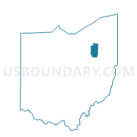
Neighbors
Neighoring Voting District (by Name) Neighboring Voting District on the Map
- Voting District CHIPPEWA TWP 9, Wayne County, OH
- PRECINCT BARBERTON 3-C, Summit County, OH
- PRECINCT CLINTON VILL, Summit County, OH
- PRECINCT COVENTRY I, Summit County, OH
- PRECINCT NEW FRANKLIN 1-A, Summit County, OH
- PRECINCT NEW FRANKLIN 1-B, Summit County, OH
- PRECINCT NEW FRANKLIN 1-C, Summit County, OH
- PRECINCT NEW FRANKLIN 3-A, Summit County, OH
- PRECINCT NEW FRANKLIN 3-B, Summit County, OH
- PRECINCT NEW FRANKLIN 4-A, Summit County, OH
- PRECINCT NEW FRANKLIN 4-B, Summit County, OH
Top 10 Neighboring County Subdivision (by Population) Neighboring County Subdivision on the Map
- Barberton city, Summit County, OH (26,550)
- New Franklin city, Summit County, OH (14,227)
- Coventry township, Summit County, OH (10,945)
- Chippewa township, Wayne County, OH (10,212)
- Clinton village, Summit County, OH (1,214)
Top 10 Neighboring Place (by Population) Neighboring Place on the Map
Top 10 Neighboring Unified School District (by Population) Neighboring Unified School District on the Map
- Norton City School District, OH (14,263)
- Coventry Local School District, OH (13,363)
- Northwest Local School District, OH (13,329)
- Chippewa Local School District, OH (9,339)
- Manchester Local School District, OH (9,069)
Top 10 Neighboring State Legislative District Lower Chamber (by Population) Neighboring State Legislative District Lower Chamber on the Map
- State House District 43, OH (126,658)
- State House District 3, OH (114,520)
- State House District 45, OH (107,689)
Top 10 Neighboring State Legislative District Upper Chamber (by Population) Neighboring State Legislative District Upper Chamber on the Map
- State Senate District 22, OH (370,237)
- State Senate District 28, OH (354,926)
- State Senate District 27, OH (348,274)
Top 10 Neighboring 111th Congressional District (by Population) Neighboring 111th Congressional District on the Map
Top 10 Neighboring Census Tract (by Population) Neighboring Census Tract on the Map
- Census Tract 5103.02, Summit County, OH (5,943)
- Census Tract 5103.01, Summit County, OH (5,339)
- Census Tract 29.02, Wayne County, OH (5,285)
- Census Tract 5317.02, Summit County, OH (4,308)
- Census Tract 5316.01, Summit County, OH (4,304)
- Census Tract 5317.01, Summit County, OH (3,852)